Over the past three decades, China's rapid economic growth has sped up the urbanization in its southern coastal regions. This led to a boost in urban motor traffic, which exerted great pressure on the environment and transportation. Current thoughts on urban development emphasize the protection of the natural environment, energy consumption in buildings, and the reduction of green house gases. The MPS could play a larger role in the urban transportation system, and it would help reduce the dependence on the motor traffic, make good use of the urban public transport facilities, save land for environmental projects, and reshape the urban space to make it conducive to social activities[1]. Also, it would help the citizens accept this ecological and sustainable way of traveling around.
With its unitary property rights, clear functions, and environmental integrity, the university campus has all the features suitable for the practice and research of the MPS [2]. As the planners and architects of the new campus of University of Macau in Hengqin, the design team received strong support from the Board of Directors of the University. From the conception and planning till the full completion of the whole campus, the designers were able to actualize the MPS in its full and systematic version, which now extends to the whole campus, and conduct the related researches after it went into operation.
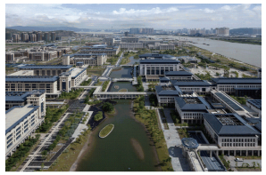
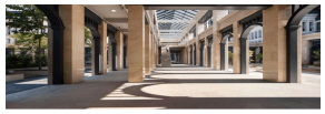
As the largest and internationally most influential institute of higher learning in the Macau Special Administrative Region, University of Macau, for future development with chosen a site in the east of Hengqin Island, located in China's southern coastal regions, for its new campus. The campus covers an area of over 109 hectares with an overall floorage of about 1 million square meters and a population of 10 000 students. The project was started in 2009 and completed in 2013. Its planning and design took into account the cultural fusion of the East and West, which is typical in Macau, the ecological feature of mountain-and-sea interplay in Hengqin Island, as well as the urban and architectural culture of the South of the Five Ridges area. The idea of making the multi-dimensional connective corridor the core of the whole transportation system is the key to the whole planning. Like a bond, the corridor integrates campus functions, traffic organization, spatial connection, and the ecological environment into an organic whole. In this project, successful attempts were made to put various urban transportation theories into practice and the required elements in a practicable campus pedestrian system were summarized, as shown in Figs. 1 and 2 respectively.
|
Figure 1 Aerial view of the new campus of University of Macau (photo by Li Yao) |
|
Figure 2 The MPS inside a cluster (photo by Li Yao) |
2 Practice for Pedestrian-Vehicle Dividing System on the New Campus of University of Macau
Pedestrian-vehicle division in the planning of roads is a prerequisite for building an MPS. Only through pedestrian-vehicle division can pedestrian-vehicle intercrossing be prevented, use of vehicles curbed, people's way of traveling changed, and campus environment improved. Pedestrian-vehicle division also serves as an objective foundation for advocating walking as a preferable way of traveling around.
2.1 Origin of the Theory of Pedestrian-Vehicle DivisionThe principle of dividing pedestrian and vehicle while organizing traffic was first proposed by Perry, who, in his “neighborhood unit” theory, believed that city traffic should not cut through a neighborhood and proposed that the street for traffic and the street for life should be separated [3].
The first neighborhood to embody the theory of pedestrian-vehicle division was the Radburn Neighborhood (planned in 1933) in New Jersey, the United States. In this neighborhood, the vehicle lane and the pedestrian lane were separated, with the vehicle lane circling the neighborhood unit and connecting the greens of various clusters and city roads, and the pedestrian lane extending into the neighborhood unit and connecting the landscape greens. Through this, an agreeable, safe, and comfortable environment was created. Driveways with branch-shape ends went deep into each residential cluster, satisfying the need of “parking nearby” [3].
2.2 Features of Pedestrian-Vehicle Dividing System in University of Macau1) The site of Hengqin Campus of University of Macau is isolated from the surrounding urban space, connected to the outside only by an undersea tunnel to the east, at the end of an urban road system. Therefore, without any traffic cutting through or any urban function interfering, this unique kind of urban space can be considered as a closed system. Free from external interference, the project has great advantage in practicing pedestrian-vehicle division and the results of the researches would be greatly feasible.
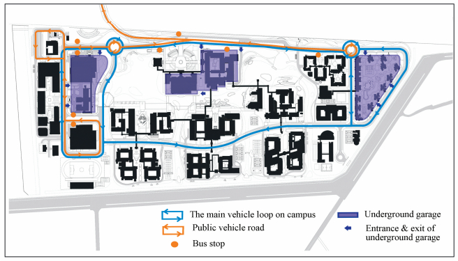
2) The planning of vehicle traffic on the new campus of University of Macau includes three features: the main vehicle loop system circling the campus, an integrated underground garage system for three major clusters, and a public transport system that involves both the internal and external areas. A complete vehicle traffic system provides a foundation for pedestrian-vehicle division, which should eliminate the mutual interference between pedestrian and vehicle.
According to regular campus traffic planning, each functional cluster must have its own vehicle branch system connecting with the main vehicle loop system, so as to create a crisscrossing network of vehicle traffic on campus[4]. In planning the transportation system for University of Macau, we practiced a mode of traffic organization that featured a main vehicle loop system coupled with an MPS. To reduce the number of vehicle branches, we increased the proportion of pedestrian facilities in the campus transportation system. The main vehicle loop system was located outside the teaching clusters and central landscape area, creating smooth internal vehicle traffic, straight or curve, within the campus while linking all the functional clusters together. Vehicles could not go inside the pedestrian area, leaving the traffic space within and between the functional clusters to the MPS. As a result, there is “vehicle” and “mobility” outside and “pedestrian” and “tranquility” inside. Since the vehicles are strictly limited in the areas they can traverse, intrusion into the inside of the clusters by motor traffic is avoided, thus creating a comfortable environment for walking and a quiet environment for living and studying. We have made a contrastive analysis (listed in Table 1) on the different modes of traffic organization inside the clusters. Both the research results and the practice show that cluster planning featuring an MPS is conducive to pedestrian-vehicle division. The key lies in the transition and linking of transportation functions between the main vehicle loop system and the MPS as well as the smooth, efficient, and accessible operation of the MPS. In order to provide accessibility for special vehicles such as those for fire fighting, medical care, and maintenance, the MPS is also allowed to serve a vehicle branch on special occasions. This is a measure that further reduces land use, narrows the scope of vehicle mobility, and ensures the integrity and continuance of the pedestrian space as displayed in Fig. 3.
| Table 1 Contrastive analysis on linking methods between cluster and road |
|
Figure 3 Analysis of vehicle traffic on campus |
The integrated underground garage for the three major clusters is located in the east of the campus, bordering on the outside urban traffic. The three major clusters include, from north to south, the administrative and academic exchange cluster, the central teaching cluster, and the teacher's living cluster. In the future, vehicles on campus and visiting vehicles from the outside will be parked in these three underground garages. On the ground, access of cars into the academic area will be effectively restricted. To the north of the campus will be a large open-air bus station. Inside the campus, except for a few parking plots on the ground, no other parking places will be built for other clusters. Due to the university's effective regulation on vehicles, over 70% of the cars never go into the main loop road inside the campus. The parking system has produced unexpectedly good results.
Public transport that involves both the internal and external areas of the campus is indispensable to the pedestrian-vehicle dividing system. Its highly effective carrying power would compensate for the inadequacy of the pedestrian system in long-distance traveling and reduce the dependence on private cars. In areas with a single route, the effect would be even more obvious. To the north of the campus, therefore, the large bus station is built, with sufficient carrying power.
3) Cycling is a good way of traveling that is environmentally-friendly and low-carbon. With its speed and use distance more favorable than walking, it is an effective complement to the pedestrian system on campus and should also be incorporated into the pedestrian-vehicle dividing system[5]. University of Macau has built up a sound cycling traffic system. During road planning, a cycling lane is reserved along the loop system circling the campus. Moreover, bicycles can go deep into various building clusters. Abundant bicycle parking area is also reserved in the empty ground space of various buildings, so as to encourage the students and teachers to use bicycles instead of cars for traveling.
3 Practice for MPS on the New Campus of University of MacauJan Gehl, a Danish planner, believes that “walking is not only a mode of transportation, but also an opportunity for taking an exercise, breathing fresh air, and taking a stroll”[6-7]. In short, a pedestrian system should be a close integration of transportation and livability; the key words for a campus pedestrian system should be convenience, efficiency, safety, and comfort. Specific measures to facilitate transportation are those that make traveling multi-dimensional, short-distance, and weather-resistant. Measures to ensure livability include integration with nature, respect for the environment, and sharing of landscape.
3.1 Multi-Dimensions, Short-Distance and Weather-ResistanceA multi-dimensional connective corridor is the key to the efficient and convenient operation of the pedestrian system.After practical test, two important conceptions during design and planning are considered to have produced good results. 1) Pedestrian-vehicle division has brought convenience and safety to the transportation system. The underground garage, with its integrated parking, has guaranteed the division between pedestrian and vehicle traffic, leaving complete spaces on the ground to the pedestrian system. Most of the pedestrian routes are free from interference from vehicles. Even the walk across the loop road is via a second-floor connective corridor. 2) The cluster planning of buildings, the network of connective corridors among the clusters, and the traffic space within the buildings themselves bring smooth and effective transportation among the clusters. Through contrastive analysis (listed in Table 2), it has been proved that an MPS constructed in this way has a clear structure as well as makes effective use of the connective corridors between buildings.
| Table 2 Contrastive analysis on the organization modes of pedestrian systems |
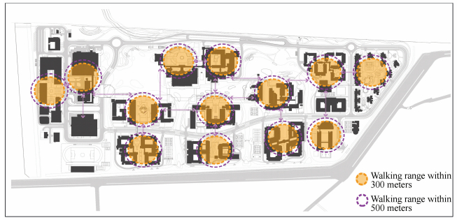
Judging from the size and scale of the site, the Hengqin Campus of University of Macau is suitable for a campus transportation system that features walking. Based on this condition, two effective measures were employed to control the distance of walking. 1) Since walking consumes physical energy, the distance of walking should be kept within a comfortable range. Generally speaking, it is acceptable for an average person to walk 5 to 10 minutes. Walking over 10 minutes makes one tired, so the distance should be kept between 300 to 500 meters [8]. Therefore, the size of the clusters and the distance between them were controlled on the basis of the comfortable walking range within 300 meters as displayed in Fig. 4. It has been proved that such control would result in an intensive use of land resources and an efficient organization of the traffic space between and within the building clusters. 2) In terms of planning and layout, the student's living clusters were made to surround the teaching and faculty clusters at the core, thus shortening the distance for the students to reach the teaching space.
|
Figure 4 Analysis of walking distance on campus |
Linked by clear-cut and streamlined multi-dimensional connective corridors, the clusters were spaced out at distances of between 300 to 500 meters, meeting the internationally agreed standard for comfortable distance of walking[9].
Zhuhai has a mild subtropical maritime climate, which brings abundant rainfall, with an annual average temperature of 22.6 ℃ and the highest temperature of 38.7 ℃. Located on Zhuhai's Hengqin Island, bordering on the Litchi Bay Creek and the sea on the east and falling back on the Great Hengqin Mountain on the southwest, the new campus of University of Macau enjoys a superb natural environment, with excellent conditions for natural ventilation. Influenced by the subtropical monsoon, the climate of this area features a hot summer, a large number of rainy days, and plenty of typhoons. From April to September, the southeasterly monsoon prevails, creating the rainy season. Therefore, a weather-resistant design is an important guarantee for usability, safety, and comfort[10]. Whether it's the roofed connective corridor systems between and within clusters or the enclosed building clusters, the MPS is designed in every way to meet the practical requirements of ventilation, sheltering from rain and sun, and wind resistance.
3.2 Integration with Nature, Respect for the Environment, and Sharing of LandscapeTraditional Chinese philosophy advocates a plain perspective on nature, that is, “the integration of man and nature”. Translated into the modern language, it means that human activities should be compatible with nature, thus creating a favorable relationship of coexistence[11]. This view goes along with the idea of sustainable urban development. Twenty years ago, Hengqin Island, the site of our project, was still a place where man and nature existed on good terms. People lived on agriculture. They coexisted with the creeks that crisscrossed the island, the rolling wetlands along the coast, and the stretching forests, forming a harmonious ecological system. However, with the economic boom and accelerated urbanization process, the original natural scenery gave way to high rises [12]. Therefore, the design team tried to recreate a harmonious scene within University of Macau where man and nature could get along. According to the conditions of the base, the general planning involves a scientific examination of the soil ingredients and the surrounding natural water quality.Meanwhile, the designers also made a contrastive research into the wetland conservation project, which was only two kilometers away. This project, since its implementation, has been in existence for a decade and achieved its intended results, with a large number of southern wetland plants successfully planted on the coast, providing a favorable habitat and feeding place for birds.Based on comprehensive research and analysis, the gentle landform, the creek on the north, and the coastal location are all important conditions for restoring the environmental structure that features islands, lakes, creeks, and wetlands.The soil ingredients and water quality, as well as the nearby successful example, prove that it is possible to grow wetland plants with local characteristics to create an ecological natural environment. The MPS is the core link in this process, since the pedestrian-vehicle dividing system has ensured the integrity of the land for the environment, minimized the encroachment of the road network upon it, and left sufficient space for shaping the ecology of the campus.Walking-based human activity, as a result, has greatly reduced its interference on the natural environment, creating a safe and quiet atmosphere for attracting birds to inhabit here.
The multi-dimensional connective corridors are at the core of the pedestrian system, though not the whole of it. The connective corridor system, through its strong transportation functions, connects the walking space of the central landscape, the sidewalk of the roads, and the touring paths in the environment into a pedestrian system that spreads across the whole campus.In this network, the buildings clusters, the gardens inside them, the ecological environment of the campus, and the outdoor public square become an organic whole.A multi-functional, multi-level, multi-type pedestrian system is a participator, not a spectator, of the environment, thus achieving a fantastic fusion with nature.
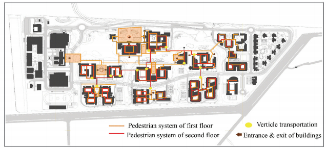
Traditional Chinese thoughts on landscape design advocate the idea of “scenery changing with each step”.Translated in modern language, it means that the walking space must be designed in relation to the needs of landscape watching. As one walks, they should experience diversified views, thus bringing relaxation and pleasure to the mind[13]. The blueprint of campus planning portrays four levels of landscape space, which arranged by size, include the central landscape, landscape between clusters, courtyards within clusters, and platforms in buildings for landscape watching and other activities. As displayed in Fig. 5, the corresponding pedestrian system includes the walking space in the central landscape, connective corridors between clusters, connective corridors within clusters, and vertical transportation (with analysis charts).
|
Figure 5 Analysis of the MPS on campus |
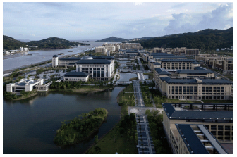
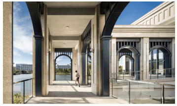
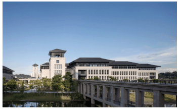
The layout of the walking routes serves three purposes, as shown in Figs. 6, 7 and 8. 1) It maintains the integrity of the landscape theme, so as to ensure that the transportation functions does not infringe upon the ecology, leisure, and privacy of the landscape environment. 2) It preserves the effect of landscape watching, so as to make the pedestrian system a touring path on campus, on the premise that it meets all the transportation needs. 3) While meeting the needs of landscape watching, it also considers the connective corridors part of the landscape. Their arrangement should go along with the buildings, bridges, roads, and landscape elements. Their design should also be compatible with the form and style of the buildings.
|
Figure 6 Aerial view of the center landscape of University of Macau (photo by Li Yao) |
|
Figure 7 The MPS between the clusters (photo by Li Yao) |
|
Figure 8 The MPS connecting (photo by Li Yao) |
4 Conclusions
1) The application of the pedestrian-vehicle dividing system is the key to the construction of an MPS on a college campus. By incorporating the theory of pedestrian-vehicle division into the general planning of the campus, the designers can effectively limit the scope and intensity of vehicle use and obtain sufficient and safe public space for the construction of a pedestrian system. After pedestrians and vehicles establish their own sphere of movement, walking and cycling will grow remarkably in daily life. As a result, the dependence on vehicles will decrease [14].During the conception of the MPS, the design team worried about people not being able to shake off their dependence on vehicles. However, through a combination of planning and regulation, the actual effect is beyond our expectation. The design of complete pedestrian-vehicle division not only contributes to a healthy way of traveling, but also raises the general ecological and environmental indicators on campus, with students and teachers getting fresher air and fewer noises.
2) The function arrangement in the general planning should be compatible with the MPS of the campus. The cluster planning employed by University of Macau was conducive to the application of a pedestrian-vehicle dividing system that features multi-dimensional walking. The main vehicle loop road, assisted by the pedestrian system, could effectively integrate the motor traffic of the whole campus. As a result, a comprehensive transportation system that combines vehicle and pedestrian is created, bringing into full play the transportation functions of the MPS. In the organization of transportation within the clusters, the MPS played an even more obvious role. It simplifies the docking to the main loop road, largely reduces the area of roads, and, as a result, ensures the efficient operation of the main loop road. During research, we find that a thorough pedestrian-vehicle division and a clear planning structure are the prerequisite for the realization of the MPS. Multi-dimension is a technical measure to realize the spatial relationships of building and transportation[15]. Short-distance embodies reasonable control over the planning. Weather-resistance reflects the double needs of function and humanity.
3) The MPS should meet not only the functional needs, but also the humanistic needs. South China has a hot climate, with a large amount of rainfall and typhoon. Therefore, the connective corridor suits the local climatic conditions, since it pays special attention to the user comfort. The MPS, in combination with the landscape on campus, gives the students and teachers a good view and touch in daily walking, so that they can relax their mind and get closer to nature. As a result, they should be more willing to choose walking as a way of traveling. In the 2014 survey after the completion of the project, among the 117 random interviewees, 106(90.5%) believed that the pedestrian-vehicle dividing system within campus posed no threat to the convenience of traveling.88 interviewees(75.2%) said they preferred walking, cycling, or taking a bus as a way of traveling. 96 interviewees (82.1%) believed that the MPS was conducive to socialization and recreation. The transportation function, convenience, comfort and pleasure brought by the MPS has been recognized by the majority of people.
| [1] |
Bacon E N.
Design of Cities. USA: Penguin Books, 1976 : 7 -11.
( 0) 0)
|
| [2] |
He Jingtang, Deng Jianhong, Tu Huijun. Design local and ecological campus.
Journal of Urban Planning Forum, 2002 (5) : 43-45.
( 0) 0)
|
| [3] |
Pastier J.
Cesar Pelli. USA: Whitney Library of Design, 1980 : 2 -8.
( 0) 0)
|
| [4] |
He Jingtang. Several trends in campus planning and design.
Journal of New Architecture, 2002 (4) : 5-7.
( 0) 0)
|
| [5] |
Carlos J, Balsas L. Sustainable transportation planning on college campuses.
Journal of Transport Policy, 2003 , 10 : 35-49.
DOI:10.1016/S0967-070X(02)00028-8 ( 0) 0)
|
| [6] |
Gehl J.
Cities for People. London: Island Press, 2010 : 4 -16.
( 0) 0)
|
| [7] |
Gehl J.
Life between Buildings:Using Public Space. London: Island Press, 2011 : 1 -15.
( 0) 0)
|
| [8] |
Tao Zhi, Gong Yue. The study on the pedestrian model in campus.
Journal of City Planning Review, 2002 , 26 (10) : 55-56.
( 0) 0)
|
| [9] |
He Jingtang, Guo Weihong, Wu Zhongping. Planning of Guangdong Pharmaceutical University.
Architectural Journal, 2005 (11) : 18-20.
( 0) 0)
|
| [10] |
Images Publishing.
The City in Architecture—Recent Works of Rocco Design Limited. Australia: Images Publishing, 2002 : 3 -9.
( 0) 0)
|
| [11] |
Peng Yigang.
Analysis of the Traditional Chinese Garden. Beijing: China Architecture & Building Press, 1986 : 6 -13.
( 0) 0)
|
| [12] |
Kempenaar A, Westerink J, Lierop van M, et al. Design makes you understand—Mapping the constributions of designing to regional planning and development.
Journal of Landscape and Urban Planning, 2016 (149) : 20-30.
( 0) 0)
|
| [13] |
Liu Dunzhen.
Classical Gardens of Suzhou. Beijing: China Architecture & Building Press, 2002 : 3 -20.
( 0) 0)
|
| [14] |
Matloob F A, Sulaiman A B, Ali T H, et al. Sustaining campuses through physical character—The role of landscape.
Journal of Procedia-Social and Behavioral Sciences, 2014 (140) : 282-290.
( 0) 0)
|
| [15] |
Xu Junbin, Zhang Zhiyong, Rong Jian. The campus road planning and design research.
Journal of Procedia-Social and Behavioral Sciences, 2012 (43) : 579-586.
( 0) 0)
|
 2016, Vol. 23


 Building
 Multi-dimensional pedestrian system


 Building
 Vehicle road
  Commercial shops plaza
  Multi-dimensional pedestrian system


